See “NEW” tab above for the final numbers current to may 2020.
New proposed School Field would be 78,000 sf and approaching the size the district said it would be Back in September

short VERSION
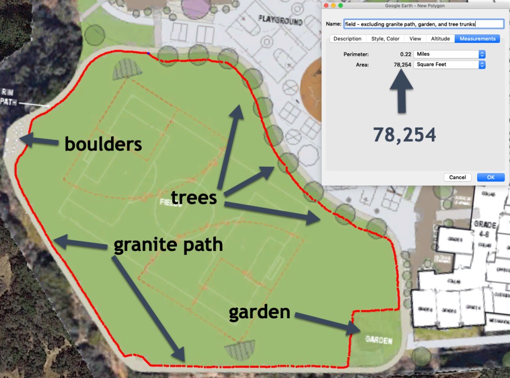
The new January 22 field design is 78,000 square feet – 49% of the size of today’s fields (160,000 sf). To their credit, this time the district did actually enlarge the play field – adding about 16,000 sf.
We’re grateful the district actually made some movement after four months of public uproar, for sure. On the other hand, even with their movement in the latest design, the field is still less than the 79,221 sf that they told us the field was on September 12, 2019 in the Del Mar Times. That number was what caused the public uproar in the first place . . . and was the genesis of Play Outside Del Mar. So while we seem to have made some progress, we’re also right where we started.
The district continues to mislead us by: (1) counting the previously excluded decomposed granite path and boulders around the field as grass, adding 8,829 sf and (2) counting the previously excluded garden as grass, adding 2,662 sf, and (3) counting the tree trunks as field-game playable areas, adding 2,468 sf. That is how they stair-step up to their advertised new number of 92,213 sf.
We’ll show you everything below, with a few new photos showing you how the district includes garden and boulders in calculating the field square footage in their latest design (to make the proposed fields seem bigger, like less is being lost) but excludes the very same things and more in calculating what the field square footage is on today’s fields at the Heights (to make today’s fields seem smaller, like less is being lost). Make your own judgments about that.
A few weeks ago, we gave you the full story about how the district secretly shifted their counting methodology in the November 20 design to claim a field size increase of 17,000 sf without actually enlarging the field at all – changing from not counting the granite path, boulders, garden, drainage bio-swales, etc., to counting them as grass playfields. We’re going to skip all that detail here and get right to the January 22 site design measurements. If you’re a first time reader who wants to know the full story, you can take a look at what we wrote earlier by CLICKING HERE.
The measurements – Jan 22 UPDATED design
Let’s get to the bottom line, courtesy of Google Earth’s measurements.
Our measurement: about 78,000 sf
Here you can see how we get 78,254 (the area inside the red path). We included all the grass playing field, even up to the very edge of the decomposed granite path. We excluded the granite path itself, the boulders, the garden on the southeast corner, and a tad for the tree trunks where regular field games are not safely playable.
DISTRICT EXAGGERATION: INCLUDING GRANITE path, Boulders, GARDEN, AND TREES
Below, you can see how the district gets 92,213 – by including the granite path, boulders, garden, and trees. We actually measure a few feet more, maybe our mouse was shaking during the trace. As you can see, we’ve traced outside the granite path, including that plus boulders, garden, and tree trunks. This is apparently what the district did to reach their number – as we are within about 100 sf of them (0.1%)

The next visual shows you that by counting granite path and boulders as grass, the district artificially added 8,829 to their square footage. We get this by comparing 92,213 (field including granite path and boulders) to 83,244 (field excluding granite path and boulders).

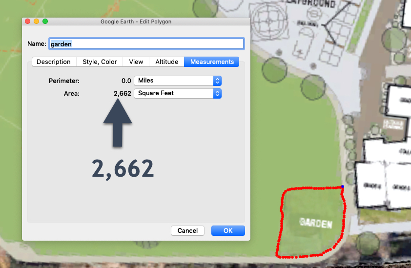
The next visual shows you that the district artificially added another 2,662 sf of field space, simply by counting garden as grass.
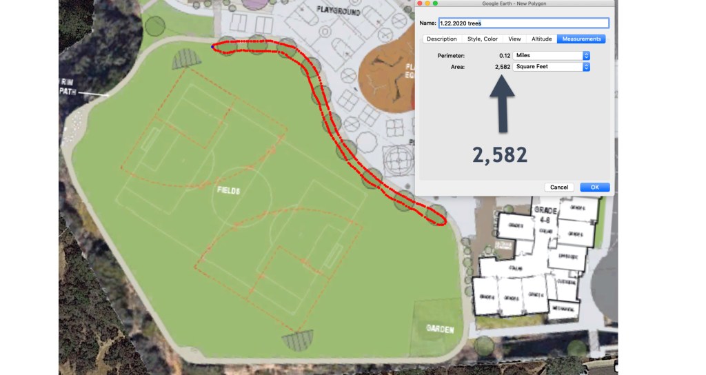
The next visual shows you that by counting the areas of the field covered by tree trunks as field-playable areas, the district artificially added an additional 2,582 sf of field.
That’s it for the math. The field is about 78,000 sf. When you do what the district does – add the granite path, boulders, garden, and tree trunks, you get about 92,000 sf.
the district FLIPS AND excludes the garden and the boulders when it serves their purpose – to make the loss of CURRENT field seem smaller
Back in October 2019, the district published this photo in the Del Mar Times.

We’ve added the arrows and all of the white type except for the 146,195 square foot number, which the district put there.
The point is: when the district has incentive to make the current Heights’ fields smaller to convince the public less square footage is being taken away – the district excludes the garden from its square footage and excludes the boulders at the southwest corner. This is entirely proper – and what we ourselves do – because the garden is not a playing field and the boulders are not a playing field. Yet when the district has incentive to make the fields in the January 22 design seem larger than they are, it includes the garden and the boulders and even the entire granite path to reach for their inflated field size of 92,213.
A more glaring example is the district excluding the baseball fields from “fields” in the photo above to reduce field square footage today, but then including the baseball fields in their January 22 calculations to make the new fields seem larger. The baseball fields should be included both today and tomorrow. They are fields, not only for baseball, but often used by the kids for other play.
Note also that today – most recently at the January 22 board meeting – the district claims the entirety of the green space at the current school is only 126,367! How is that possible if the fields alone were 146,195 sf back in October – which is what the photo above says.
why do our measurements show a 19,000 sf increase when the district says only 16,000 sf?
This borders on minutia, but if you want to know, read on.
For those of you who have carefully followed our earlier analysis of the district’s fields, you might wonder why our January 22 measurement of 78,000 sf is actually a 19,000 sf bump in field size compared to our November measurement of 59,000 sf, rather than the 16,000 sf increase that the district reports. Three reasons.
First, our calculations correctly exclude the garden, and the district’s new design purports to shrink the garden from 3,445 to 2,662 in the latest design. That would bump up the field size we calculate, because a smaller garden means more playable grass field. It would not, however, bump up the district’s Jan 22 measurements because the district already improperly included all of the garden in their November calculations.
Second, we previously excluded the on-field drainage bio-swales from our field size (because they are un-playable drainage ditches). Those have now disappeared from view in the district’s design, so that bumps up our number a bit. We figure they are likely just hidden from sight and that we’ll have to shrink our calculations once they re-appear, but for now we’ll take the district’s site plan at face value.
Third, we previously excluded a very small area of field in the southwest corner because of boulders on the field. Those boulders seem to have been moved onto the far west part of the granite path, as we’ve pointed out above, resulting in a small increase in size in our measurement because we now include the grass area where the boulders used to be. As with the bio-swales, we’ll have to see whether they’ve really been moved onto the granite path.
Thanks for listening.
Details of our measurement methodology
- Computer and satellite imagery using the district plans as a semi-transparent overlay – checking our system calibration to 99% accuracy against other objects with known dimensions. We used five independent methodologies for taking and verifying the measurements, and checked and double checked the measurements and math on each approach. The methodologies all confirmed each other. We’ll spare you the geek speak for now on the exact details of the approaches.
- Taking physical measurements on the ground at the Heights using the district’s plan and taking rolling measurements like old surveyors, calibrating and double checking the calibration and accuracy with lasers and also traditional tape measures. These approaches – which were done from scratch without any data carried over from the earlier methods – independently synced with the computer and satellite measurements.
