district still exaggerates field size by 17,000 square feet – 29%!
It’s easy to show that the district’s measurements are seriously wrong. We know, however, that will only raise questions as to how they could make yet another mistake, and raise questions as to what they did to make the mistake. As a result, we spent time getting you answers before writing this. We will now show you how we know.
If you want to know how the district responded when we asked them about the discrepancy, including our formal public records request, read or scroll to the bottom.
short VERSION
The currently-proposed field is 59,000 square feet (sf) – down from 160,000 sf at the school today. To get their exaggerated number of 76,020 sf, the district mostly did nothing to enlarge the field as recently claimed, but instead changed what they counted as field without telling us about the change in method. They: (1) counted the previously excluded decomposed granite path around the field as grass, adding 7,955 sf, (2) counted the previously excluded garden as grass, adding 3,445 sf, and (3) counted the bio-swales and tree trunks as field-game playable areas, adding 4,003 sf.
Let’s not lose sight of the facts: the field is 59,000 sf.
THE DETAILS
original field – september 12
On September 12, 2019, the district provided their first field measurements – 79,221 sf as shown below.
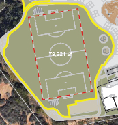
Notice two things. First, pay attention to the shape of the field encircled in yellow, especially the bottom “boat keel” shape and the far West “nose” that is outside the yellow border.
Second, notice the grey path around the field – which is a decomposed granite path – and you’ll see that the yellow border doesn’t cover it entirely, but instead covers only the inside edge of it. That’s because the inside edge of the yellow border abuts the start of the grass field. This means the district originally measured the grass “field” only as area inside the yellow boundary, and did not include the granite under or outside the yellow. Solid methodology: granite is not grass or field.
Keep in mind the alleged square footage of 79,221 sf. We measured it (using several independent methodologies) as 57,500 – and then let the public know about the 22,000 square foot error on November 13.
NEW, ALLEGEDLY “LARGER” FIELD – NOVEMBER 20
No response by the district, until the November 20 board meeting, where they announced a 9% increase in field size. Encouraging news, we thought, though it seemed suspicious they omitted the actual square footage. The board echoed their “9% increase” messaging a week later in the November 28 issue of the Del Mar Times, headlined the article by claiming they had increased the field size by 9%. Board president Erica Halpern touted this as a “pretty impressive response” to the community feedback for more fields.
That’s when they unveiled the new field size of 76,020.
Of course this raised our eyebrows. We thought 9% more would have resulted in a field that was 9% more, not 4% less than the 79,221 previously reported. In other words, we expected 86,530, rather than 76,020. That raised a question. We also wondered whether 76,020 itself was now an accurate number or just as bad as the 79,221 which we’d shown to be 57,500.
To answer these questions, we studied the new drawings of the “9% larger field,” shown below at right, next to the “original field” at left.

First Proposed Field – Sept 12

Second “Larger” Field – November 20
A couple things quickly stood out. First, the bottom shape of the November 20 field was different – the “boat keel” carveout at bottom was gone; all areas to the left and right of it were now included as “field.” This meant the district was not actually enlarging the field there, but instead changing their counting method there, to count granite (left of the keel) and garden (right of the keel), as the new grass. The second granite as grass switch was on the West-facing nose of the field – it was obvious the district was also going to count that granite as grass.
What was not immediately obvious – this took careful study – was that the district actually decided to count the entire granite path encircling the field as grass. This last granite as grass switch, we would learn, added nearly 8,000 sf to the size of the field as measured by the district, without changing the size of the field at all. How clever! We’ll show you this last one further below in our measurements.
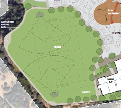
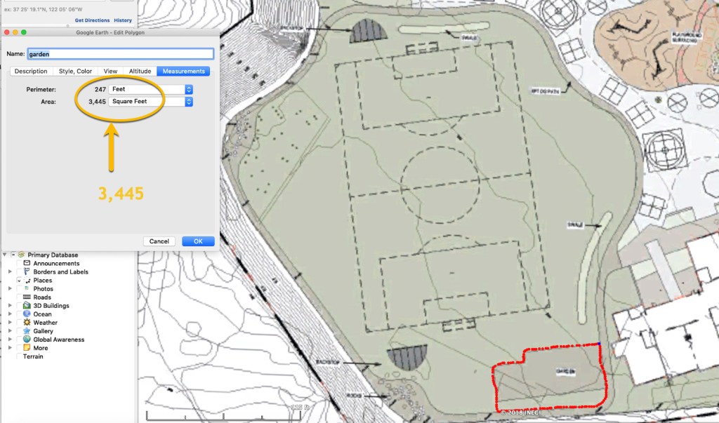
First, though, let’s take a deeper look at the district including the garden (previously excluded) in the count of field square footage. This was a change – not in the actual field size, but in the counting methodology. You can get a good sense of the “garden for grass” switch from viewing the three images below.
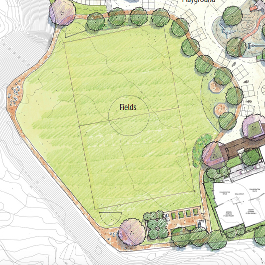
The first image properly excludes the garden to the right of the boat keel; the second shows clearly that it is a garden, and the third shows the garden is now included in the field measurements even though the field itself has not changed. This garden for grass switch in methodology added nearly 4,000 sf to the field size reported by the district without changing anything at all. Once again, clever!
Now some among you might wonder: “Maybe they are eliminating the garden to gain field space, rather than just hiding it in the calculations.” That’s a fair question. But as you can see, they have answered that for us in other diagrams on November 20 and later. It’s crystal clear: the garden is still there.

The measurements
Let’s get to the bottom line, courtesy of Google Earth’s measurements.
Our measurement: about 59,000 sf
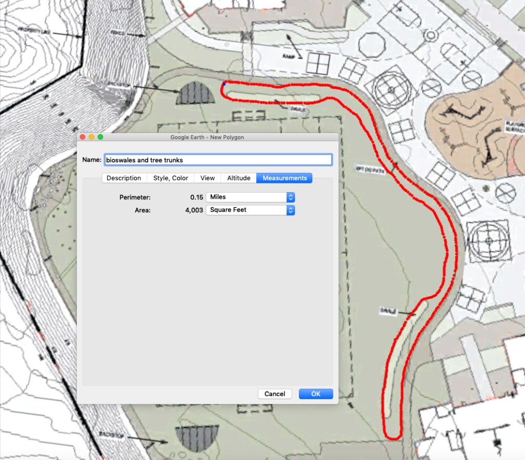
Here you can see how we got 59,386 (the area inside the red path). This is a plan view diagram from the district’s latest site plan. We included all the field, even up to the very edge of the granite path. We excluded the granite path itself, the rock garden at the southwest corner, the garden on the South, the two bio-swales (worm-shaped water drainage ditches that are unplayable), and a tad for the tree trunks (you can see them in the figure immediately above) on the East and North.

DISTRICT EXAGGERATION: INCLUDING GRANITE, GARDEN, BIO-SWALES, AND TREES
Below, you can see how the district gets 76,020 – by including granite, garden, drainage ditches, and trees. We actually measure a few feet more, but maybe too much coffee and our mouse was shaking during the trace. As you can see, we’ve traced outside the granite path, including that, plus the garden, bio-swales, and trees. This is apparently what the district did.
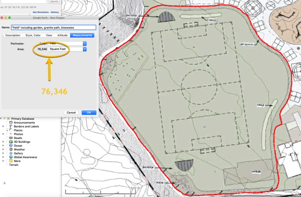
The next visual shows you that by counting granite as grass, the district added 7,955 square feet to their square footage, without changing anything on the field. We get this by: 76,346 (including granite) minus 68,391 (excluding granite).

The next visual shows you that the district added another 3,445 of field space, simply by counting garden as grass.
The next visual shows the bio-swales and tree trunks account for about 4,000 sf.
That’s it for the math. You’ll notice there remains about 1,500 sf difference between us and the district and that seems to be because the field is indeed that much larger now. When you add that 1,500 sf to our original 57,500 sf, you get 59,000 sf. If you count granite as grass, garden as grass, bio-swales as playable areas, and tree trunks as part of the actual fields then you end up being the district.
We’ll now tell you how the district responded when we asked them to justify their numbers. But first, a super brief explanation of our measurement methods and double checks.
how we Measured
- Computer and satellite imagery using the district plans as a semi-transparent overlay – checking our system calibration to 99% accuracy against other objects with known dimensions. We used five independent methodologies for taking and verifying the measurements, and checked and double checked the measurements and math on each approach. The methodologies all confirmed each other. We’ll spare you the geek speak for now on the exact details of the approaches.
- Taking physical measurements on the ground at the Heights using the district’s plan and taking rolling measurements like old surveyors, calibrating and double checking the calibration and accuracy with lasers and also traditional tape measures. These approaches – which were done from scratch without any data carried over from the earlier methods – independently synced with the computer and satellite measurements.
THE DISTRICT’S RESPONSE
You might wonder what’s the district’s position is, on all this. All I can say is we have tried . . . and are still trying. On November 22 – the very day they announced their 76,020 figure to the Del Mar Times – we knew it was wrong. So, we sent a California Public Records Act request that afternoon, asking them for the data they had to justify their calculations. Our requests were broad enough to include surveys and anything else they used. Here’s one that’s dead on point (you’ll have to zoom to see it).


We made it easy on them, right? Their numbers were “hot off the press.” Probably the calculations were right there on their desk, handy, no real effort involved in getting us the information.
Technically they had 10 days under California law to respond, 14 more if they could justify our request as “unusually” complicated or burdensome.
Guess what? 56 days and counting (as of January 17), despite repeated follow-up on our part for information we know is on the minds of the Del Mar Community.
We’ll get it eventually, but you figure they’d actually want us to have it, if indeed it supported their claim.
